Sign up for the farmnewsNOW newsletter
Storm clouds in Meadow Lake Provincial Park after a tornado tore through two campsites over the Canada Day long weekend. (submitted/Melissa Kuzior)
DATA COLLECTION

Teams from national research project studying Meadow Lake Provincial Park tornadoes

Jul 3, 2019 | 3:05 PM

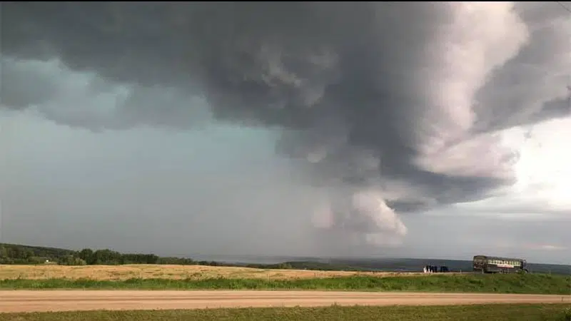
Data from two tornadoes that touched down in Meadow Lake Provincial Park will be used to better understand where tornadoes occur in Canada and how to build resiliency to them.

The Northern Tornadoes Project (NTP), a partnership between Western University, Environment and Climate Change Canada, and ImpactWx, wants to discover and decode every tornado in Canada, especially in rural and remote segments of the country.

A team of researchers are documenting damage from two tornadoes Environment Canada said skirted Murray Doell Campground and Laumans Landing northwest of Goodosoil over the Canada Day long weekend. One measured wind speeds upwards of 170 km/h, leaving a path of flipped trailers and uprooted trees in its wake.

The teams will use data from ground studies and drone and satellite images to understand the storm’s impact.

“It is a fairly complicated case,” Executive Director Dr. David Sills said. “We are trying to piece all of the parts of the puzzle together to understand what happened and, in this case, how it all relates to the radar imagery we have and the damage that was seen on the ground.”

Sills said the project is necessary as a number of tornadoes go unreported due to the vast areas of Canada that have little to no populated areas.

NTP draws on numerous data sources to study and track tornadoes. High-resolution imaging is used to analyze tree and structure damage quickly by reviewing photos taken immediately before and after a storm moves through an area.

As researchers comb through images, Sills said they find tornadoes never before known to have touched down deep in Canada’s forests and north of 60 degrees longitude.

“Sometimes we are looking for a particular tornado that occurred this year or last year and we are finding tornadoes that occurred several years ago,” he said.

He added quite a few tornadoes occur in these areas but a lack of radar and population means they go unreported. He said little is known about the actual number of tornadoes that touch down in remote regions of the country.

NTP started as a unique way to track tornadoes in northern Ontario in 2017, expanded across that province in 2018 and went national this year. It is the most comprehensive tornado analysis ever undertaken in Canada, which sees the second most tornadoes in the world, bested only by the U.S.A.

Sills said data collected through the project will help build a better sense of the severity, where and how often tornadoes occur in Canada. This will lead to improved construction practices and resiliency to the storms. The information is also used as verification data for Environment Canada’s tornado warnings and aims to help improve severe and extreme weather prediction.

“Many times [Environment Canada] issues a warning in an area that does not have a lot of population and they don’t get any feedback,” he said. “They don’t know if that tornado warning was successful or not.”

Residents who want to help researches track tornadoes can submit data via the NTP website or by using hashtags on Twitter, like #SKntp. All the data collected is open source.

tyler.marr@jpbg.ca

On Twitter: @JournoMarr

View Comments